Unit Code & Title : 5219BEUG Geomatics
Learning Outcomes assessed by the module:
1.To carry out practical surveys and setting out procedures using equipment including tapes, levels, total stations, GNSS receivers and imaging systems (to be waived).
2.To undertake relevant surveying calculations using gathered field data (data provided).
3.Undertake setting out calculations based on construction drawings (data provided).
4.To use relevant data processing, drawing and modelling software with gathered field data (evaluation of technologies).
5219BEUG Geomatics Assessment – UK.

Assessment Details :-
The assessment is based on the redevelopment of the IM Marsh Campus and involves the setting out of a building on site. Due to the emerging needs based on the coronavirus disease (COVID-19), the data set that is supposed to be collected from the site, is provided.
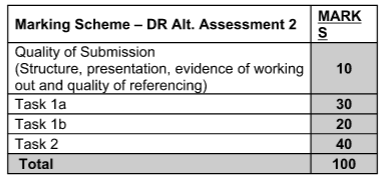
The assessment will comprise individual tasks and will account for 60% of the module mark.
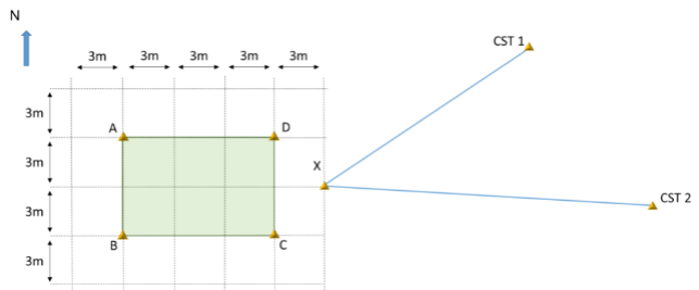
Your total station is supposed to be setup using resection to targets setup at the control stations. The corners of the building will be set out.
The completed assessment will include calculation and written tasks. The final report is to be submitted electronically as a single pdf document through Canvas on Friday, 2 nd July. Feedback will be provided on the final submission through Canvas.
The tasks and the related subtasks are given below;
Task 1:-
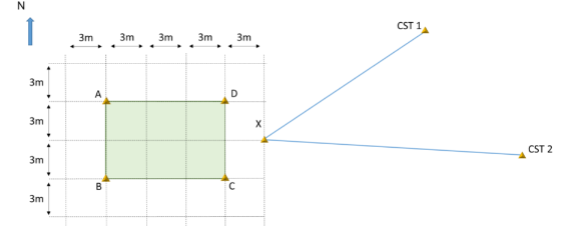
You are responsible for setting out a small building on site. The building is rectangular shaped, and it will be placed on the corner points of A, B, C and D as given in the figure. Your Total Station will be set up on point X.
Task 1 a
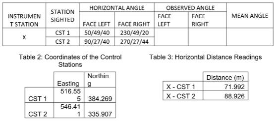
Calculate the coordinates of point X using the coordinates of CST1, CST2 and readings from your Total Station that are provided.
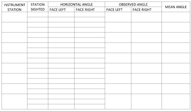
Table 1: Angle Readings taken with the Total Station
Task 1 b
Produce the data required to set out the corners of the building.
Calculate the total coordinates of the corners of the building, based on the coordinates of point X.
Please include any sketches and hand calculations used to complete tasks at the end of the Report in an Appendix.
Task 2 :-
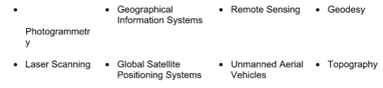
Some of the disciplines and techniques constituting geomatics are given below and you are to provide a written report to the Client of the IM Marsh Campus.
You are to select at least one* of the below options:
The report should be set out in a professional manner as you are to submit it to the client and you are to evaluate the chosen option and explain:
1. How it is/can be linked to the construction process, and
2. What are the novel applications and technologies of the chosen option within construction
Harvard Referencing is expected. Max 1500 words.
*Depending on the nature of the application you can focus on more than one.
The assignment is to be submitted electronically as a single pdf document through Canvas Friday, 2 nd July.
Blank booking sheets are attached at the end of the assignment that can either be used electronically or completed manually.
The electronic submission is to include the report as a pdf. The report is to clearly describe the steps of each calculation. The submission is to have a front cover sheet and contents page of the assignment.
Any problems should be notified to the Module Leader and penalties for late work will be in accordance with University guidelines.
ORDER This 5219BEUG Geomatics Assessment NOW And Get Instant Discount